
As part of Arcep’s work devoted to providing local authorities with more detailed information on the latest developments in mobile coverage across France, today the Authority is publishing a set of departmental maps, each of which depicts the current status of 4G coverage and its progress over the past five years.
Arcep publishes mobile coverage maps for each of the 96 departments in Metropolitan France
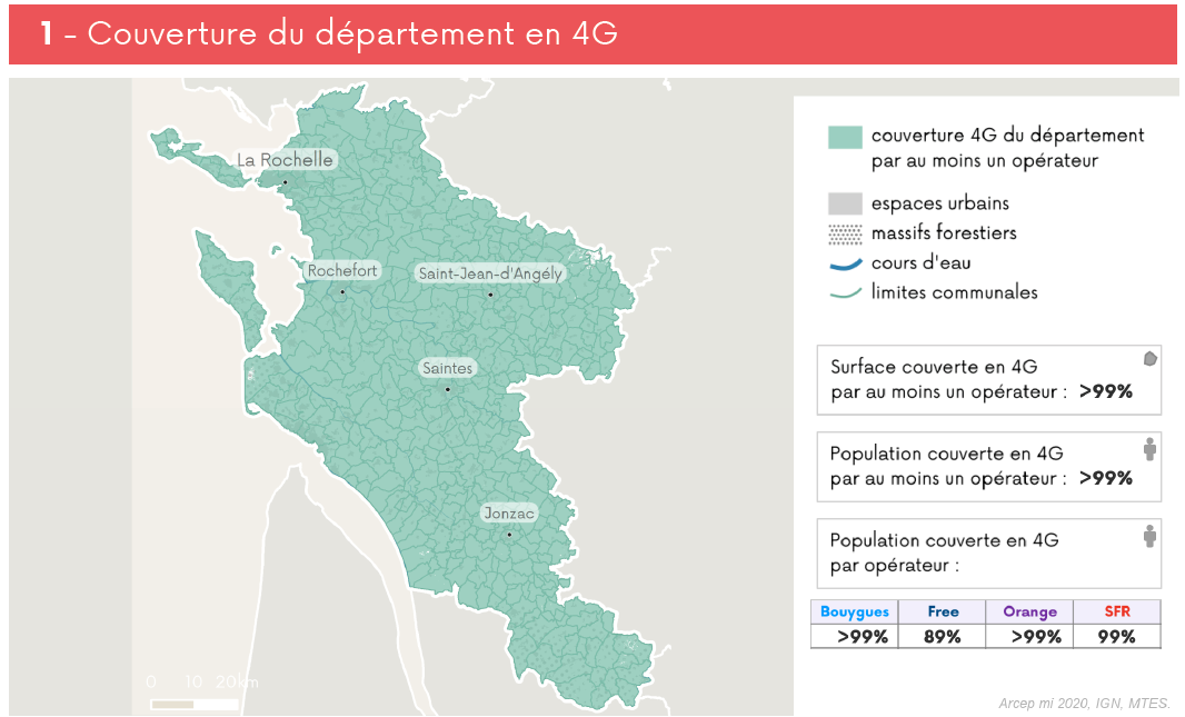
Today Arcep is publishing a set of departmental maps detailing the current state of mobile internet coverage and its progression over time.
For each department, Arcep has produced maps that illustrate:
- The department’s current 4G coverage;
- The progression of 4G coverage in the department over the past five years;
- Internet mobile (3G/4G) coverage in the department, by operator;
- The department’s 4G coverage based on the number of operators providing services there.
These maps were produced using operators’ theoretical 3G and 4G coverage data, which can be viewed on the “Mon réseau mobile” website, and already available as open data on data.gouv.fr: https://www.data.gouv.fr/fr/datasets/mon-reseau-mobile/.
In the coming weeks, Arcep will produce the same type of maps for each of France’s overseas territories.
A “turnkey” tool for local authorities and players involved in regional digital development
These maps are part of Arcep’s data-driven approach to regulation, a form of action that supplements the regulator’s traditional tools. Its underlying principle: to harness the power of information to steer the market in the right direction.
If all of these data were already available as open datasets, today they have been formatted to deliver “turnkey” information that satisfies a real need amongst local authorities and players involved in regional digital development. To give an example: these maps create the ability to visualise the steady decrease in white spots, all operators combined, between 2015 and 2020 – something that has been a major source of concern for the regional and local authorities and certain Mon réseau mobile site users. They also create the ability to track the impact of the New Deal for Mobile. Today, 10 November, marks the release of the progress report on this scheme that was implemented back in January 2018 – under the aegis of Jacqueline Gourault, Minister of Territorial Cohesion and Relations with Regional and Local Authorities, and Cédric O, Secretary of State for the Digital Transition and Communications – to achieve a dramatic increase in 4G coverage in rural areas.
This is just one of multiple use cases for mining mobile coverage data: Arcep invites every stakeholder to join this data mining effort and come up with additional ways to reuse them to satisfy their own needs.
This publication comes to complete Arcep’s existing tools for proving information on mobile coverage, namely the interactive maps found on the “Mon réseau mobile” (My mobile network) website and the and their associated open datasets.
Associated document:
• Set of departmental mobile coverage maps
• Methodological guide for understanding departmental maps 4G