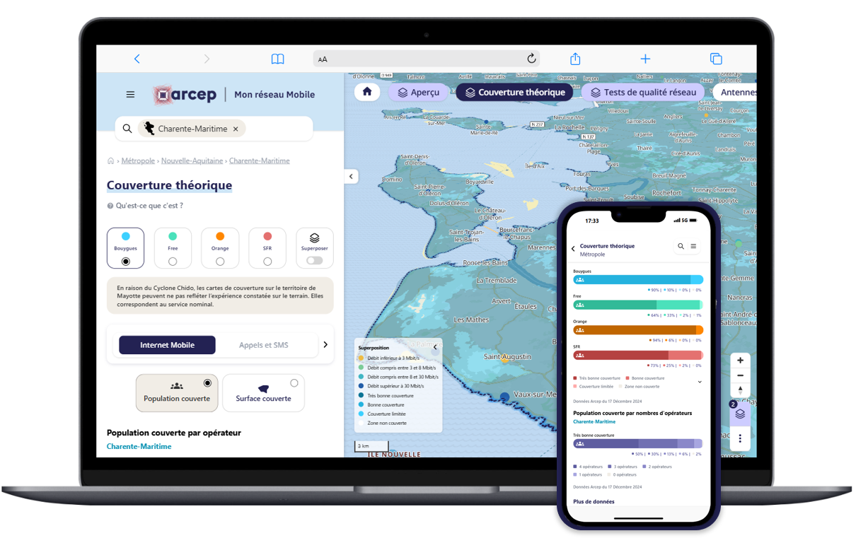
Which operator provides the best quality of service in your area? Is the road you travel every day covered by your new operator? Will there be mobile internet coverage at your holiday location, so you can access your favourite apps? Today, Arcep is releasing a new version of “Mon réseau mobile” (My mobile network) on its website, and also available as a mobile application. In addition to redesigned graphics and a more user-friendly interface, the site now provides a more detailed view of mobile internet service, with four levels of coverage.

A redesigned and more user-friendly interface, providing a more accurate reflection of mobile internet users’ experience
Over the years, users have expressed a wish to see changes to the site, to have access to more detailed and superimposable data, and to have a more user-friendly interface tailored to both computers and smartphones. Arcep took this feedback as the starting point for a complete redesign of the site.
After hosting participatory workshops, conducting online surveys on the old version of the site, as well as beta testing of the application that was release in September 2024, Arcep is delighted that so many users contributed to this project.
Data on the new version of “Mon réseau mobile” will be updated on a quarterly basis, offering:
- new four-tier 4G mobile internet maps;
- the ability to view QoS test results (e.g. perfect quality video streaming), either aggregated for all operators or for an individual operator;
- tools for address searches, measuring distance and elevation, and for exporting maps in .png format.
If, despite all of our efforts, you find a bug on the site or the app, please report it to Arcep via e-mail, along with any comments or feedbacks, to: monreseaumobile(@)arcep.fr.
New advanced features for expert users
For interested consumers and local authorities, the new version also now includes:
- territorial statistics adapted to the selected area;
- a satellite view for easier browsing of the maps;
- positions of unavailable masts/cell towers (out of service or under maintenance), updated daily.
In addition to information on the current state of the networks, users can also consult “Mon réseau mobile” to see which areas are scheduled to be covered by operators over the next 24 months, under the targeted coverage scheme. Launched in 2018 as part of the New Deal for Mobile, the aim of this mechanism is to improve local coverage in the territories by satisfying the needs of local authorities.
Lastly, to report a network outage or a decrease in an operator’s quality of service, users can click on the direct link to the “J’alerte l’Arcep” reporting site located on every map.
A field audit to verify the accuracy of operators’ new enhanced coverage maps
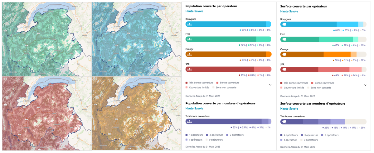
The launch of this new version of “Mon réseau mobile” also creates an opportunity to provide users with access to new enhanced mobile internet service maps[1]. They will deliver a more detailed picture and more accurately reflect the user experience, through four levels of service ranging from “no coverage” to very good coverage”[2].
These new indicators can be viewed on “Mon réseau mobile” under “Coverage”. Below is an example for the Haute-Savoie:

Before being made available online, a field audit supervised by Arcep was carried out to assess the accuracy of these maps[3], across the equivalent of 5% of Metropolitan France: more than 270,000 tests were conducted by an independent service provider.
The results of this audit reveal that, for this first edition, operators provide overall decent coverage maps on a national scale, albeit without achieving the required 98% threshold for certain areas, particularly for the most demanding “very good coverage”[4] level.
Discussions took place in response to these findings, allowing for initial corrections to be made to the maps being displayed. These discussions are part of an ongoing dialogue aimed at continuing to make the maps more accurate and ensuring that the different operators’ maps can be compared.
“Mon réseau mobile”: the first data-driven tool developed by Arcep, an integral part of its “Ambition 2030” strategy
Since 2017, the “Mon réseau mobile” (My mobile network) map-based tool has given users the ability to access two types of information for each of France’s four main operators:
• theoretical coverage maps: supplied by mobile operators, whose accuracy is verified by Arcep;
• tested quality of service: Arcep organises an annual QoS audit, under real world conditions and for a range of applications (calling web browsing, video streaming…), whose results and test locations are then published.
By urging users to choose the operator that provides the best quality of service in their area, Arcep hopes to create an incentive for operators to work on continually improving their services.
Reaffirmed in its Ambition 2030 strategy, Arcep’s “data-driven regulation” approach is based on a dual principle:
• provide the public with data, information collected by the regulator to allow them to make an informed choice of service provider, and thereby create an incentive for market players to improve;
• create a system for sharing data, information collected from users, who are on the front lines of market malfunctions, to detect weak signals and systemic issues, and to better adapt regulation to their actual needs.
This approach led to the creation of the “J’alerte l’Arcep”, “Mon réseau mobile” and “Ma connexion internet” tools, as well as annual surveys to measure user satisfaction and digital technology’s environmental footprint. Arcep is committed to continually improving the user experience thanks to the use of these tools, and to enriching the data and information made available to the public.
Steady improvement of “Mon réseau mobile”, to deliver the most accurate reflection possible of the user experience
Arcep has been steadily expanding and enhancing the data made available to users since 2017: locations carrying coverage obligations (transport corridors, points of interest, and the New Deal for Mobile targeted coverage scheme), publication of the field audits conducted by local authorities and, more recently, opening the test result data from crowdsourced QoS and speed testing apps that comply with Arcep’s Code of Conduct[5].
Links:
- Map-based network visualisation tool: monreseaumobile.arcep.fr
- open datasets: https://www.data.gouv.fr/datasets/monreseaumobile
- For more information, see the “User manual,” “Testimonials” (in French) and the other materials referred to in this press release.
[1] By virtue of Arcep Decision No. 2024-1220 of 4 June 2024: https://www.arcep.fr/uploads/tx_gsavis/24-1220.pdf
[2] Level of coverage whereby users are able access mobile data services outdoors and, in most instances, indoors.
[3] Pursuant to Decision No. 2020-0376, these maps are required to have an accuracy rate of 98%. In concrete terms, this means that tests carried out in areas stated by operators as being covered must be successful 98% of the time.
[4] In particular, three operators’ maps of “very good” mobile internet coverage sill contain at least one area where the maps’ level of local accuracy is between 95% and 97% (and so below the 98% threshold). 2G maps also contain accuracy levels that are below the required threshold in several areas for this same “very good” mobile internet coverage level (and this for all operators).
[5] In practice, two kinds of third-party data are published: first, the findings of the web browsing and speed tests collected by local authorities as part of their local audits (e.g. in the Ain and Finistère) and second, the results of speed tests conducted via crowdsourced apps, through sharing agreements with the companies (e.g. Speedchecker).
